CVG
Medium airport · United States
Cincinnati/Northern Kentucky International Airport
Cincinnati, United States · #210 world#50 of 114 in country
CVGIATA code
KCVGICAO code
9Mpassengers in 2025
3,658 mlongest of 4 runways
273 melevation · 896 ft
1947opened
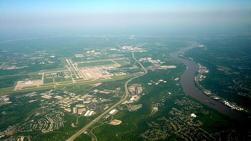
Cincinnati/Northern Kentucky International Airport (CVG/KCVG) is an airport in the United States serving Cincinnati.
It handled 8,971,128 passengers in 2025, making it number 210 in our world ranking and number 50 of 114 ranked airports in the United States.
It has 4 runways, the longest 3,658 m, at an elevation of 273 m.
4 airlines use it as a hub, including Astar Air Cargo, ABX Air and Delta Connection.
Passengers per year
2012–20256M5.7M5.9M6.3M6.8M7.8M8.9M9.1M3.6M6.3M7.6M8.7M9.2M9M
2012’122013’132014’142015’152016’162017’172018’182019’192020’202021’212022’222023’232024’242025’25
Identification
- IATA
- CVG
- ICAO
- KCVG
- Wikidata
- Q151121
Location
- Country
- United States
- City served
- Cincinnati
- Located in
- Hebron
- Coordinates
- 39.0489, -84.6678
- Elevation
- 273 m (896 ft)
Organisation
- Type
- international airport, commercial traffic aerodrome
- Opened
- 1947-01-10
- Operator
- Kenton County Airport Board
- Owner
- Kenton County Airport Board
- Named after
- Cincinnati
Runways
- 18C/36C
- 3,353 m · 11,001 ftasphalt concrete
- 09/27
- 3,658 m · 12,001 ftasphalt concrete
- 18L/36R
- 3,048 m · 10,000 ftconcrete
- 18R/36L
- 2,438 m · 7,999 ftconcrete
Hub for 4 airlines
ERAstar Air CargoGBABX AirDelta ConnectionELJDelta Private Jets